The orbit of some satellites can be influenced and predicted by weather events passing over them.
")
In addition to weather forecast, weather models may also help understand and predict how satellites react to weather eventslike the storms, cyclones, etc. that are underneath them.
Weather disturbances in satellite orbits: their forecast
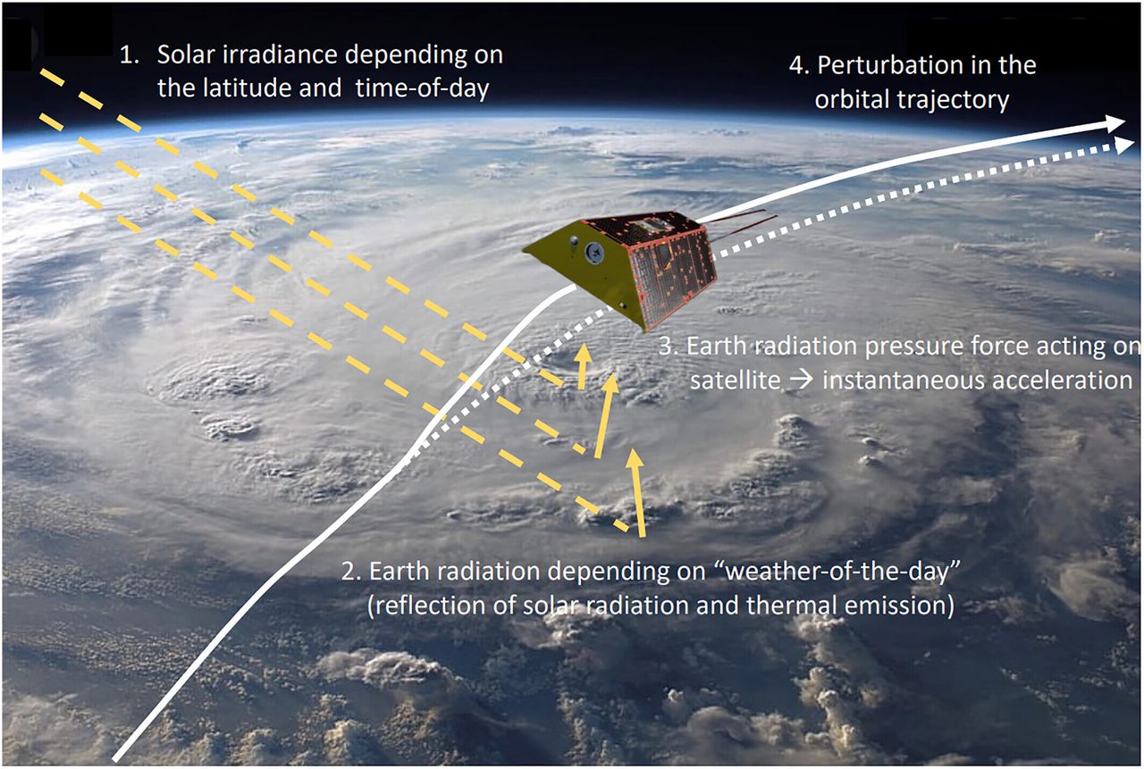
Researchers Institute for Atmospheric and Earth System Research (INAR) University of Helsinki found that modern weather models can accurately predict the energy that the Earth emits and reflects back into space, directly affecting movement of satellites in low Earth orbit (Low Earth Orbit, LEO).
Using these models, researchers obtained information about How LEO satellites react to weather events that lie below, such as tropical cyclones with high reflective clouds. The results were published in the journal Journal of Geophysical Research in April.
During the study, scientists used numerical weather models. These are complex computer simulators that predict future atmospheric conditions based on current observations and the laws of physics.
“Numerical weather models not only simulate weather conditions, but also calculate various parameters, including energy emissions and reflections of the Earth under different weather conditions.
“By analyzing these simulations, we try to understand how changes in weather, such as clouds and storms, affect the movement of satellites, affecting their ability to perform their intended functions.“, speaks Sanam Motlagzadeh, lead author of the study and doctoral researcher. in INAR.
Expanded Satellite Operations
The importance of the results obtained is that they potential for improved satellite tracking and controlimproving the efficiency and reliability of satellite operations.
“Understanding how weather affects satellites also improves the accuracy of satellite measurements used in climate research. These results address a critical issue in the reliability of satellite data, namely determining the precise orbits of satellites that are affected by atmospheric phenomena.“, explains Motlagzadeh.
Satellites play a critical role in tracking vegetation, monitoring water resources and observing the evolution of glaciers using various measurement methods. These measurements, including capture gravitational field imaging and measurements and altitude are needed to study climate change and its effects.
A better understanding of satellite movements could also assistance in weather tracking and disaster management. The use of advanced meteorological models can further refine satellite measurements, facilitating better understanding and mitigation of environmental problems.
“Understanding how satellites interact with Earth’s atmosphere provides valuable information about our planet and how it changes over time. The data obtained contributes to more accurate satellite monitoring of terrestrial water resources and, consequently, food security. ” says Motlagzadeh.
Link
S. Motlagzade and others, Weather-induced disturbances of satellite orbit, Journal of Geophysical Research: Atmosphere (2024). DOI: 10.1029/2023JD040009